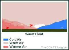
 Fronts that bring warm air are referred to as warm fronts. As this warm air approaches, it is lifted upward above the cooler air. As the air in the warm air mass rises it expands, causing it to cool down. As it cools, water vapor can condense, creating precipitation. This precipitation is generally light and forms gradually. Clouds first form in the sky as the warm air is lifted upward, proceeded by thicker clouds, and ultimately some form of precipitation. 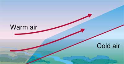 Warm fronts produce clouds when warm air replaces cold air by sliding above it. Many different cloud types can be created in this way: altocumulus, altostratus, cirrocumulus, cirrostratus, cirrus, cumulonimbus (and associated mammatus clouds), nimbostratus, stratus, and stratocumulus. 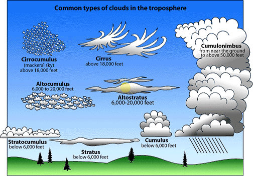 Can you spot all the clouds associated with a warm front? What kind of weather can we expect when a warm front climbs over a cold, dense, air mass? A warm front is like a transition zone where a warm air mass is replacing a cold air mass. The air behind a warm front is generally warmer and more moist than the air ahead of it. Where temperatures ahead of the front are in the 20's and 30's while behind the front they are in the 50's and 60's. 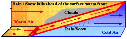 Rain, snow, ice storms will occur ahead of the warm front. When the warm front passes, the skies are clear and warmer.   Warm fronts tend to add lots of moisture for a longer period of time. If you like rain, it's not so bad. 
12 Comments
|
Mrs. TaylorI love science! Everything about the world is interesting and never boring. I love to study plants, animals, insects, and people. My favorite subjects are my students who are the most unique organisms on the planet! Categories |
 RSS Feed
